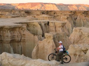
qeshm island

Introduction According to the tectonic and sedimentology evidences, we can include Qeshm as part of the south of Zagros. The external similarities as well as the existing harmony between Qeshm Island’s big anticlines and Zagros’ anticlines are some proofs confirming this idea. The effect of Namakdan mount ‘s salt dome on the west part of the island is totally obvious and has caused morphologic and tectonic changes in this part of the island.
۲.۱. The Geological and Tectonic History of the Region The north of Persian Gulf includes a part of the southeast of Zagros structural zone which has been deformed and folded as the result of the last phase of Alpine orogeny in Plio-Pleistocene. The geological formations of this belt may belong to the Late Precambrian to Cambrian and include diapirs attributed to the Precambrian called Hormoz Series, which has been active till now with a trend toward the upper formations at the earth level. According to the majority of geologists, this region -from the tectonic point of view – has been active since the Late Tertiary as the tectonic zone in the south part of the deformed forehead or the convergent belt (Mesopotamia and Persian Gulf region), along with the margins of the compression and collision plates of Iranian- Arabic continent. The region located in the southeast stretch of Persian Gulf along with Hormoz and Qeshm Islands can be identified by the structural, sedimentological and geological features such as the mainland -which is distant from it- with 2.5km width in the narrowest parts. Sea terraces of Tertiary Sediments in Qeshm Island are partially accompanied by Quaternary deposits; therefore they have resulted from the compressive tectonic forces related to Alpine orogeny. Quaternary Sea terraces very well often are horizontally stretched, while having a little slope toward the sea. The older terraces particularly those located on the anticline have a steeper slope and some mild foldings. The terraces are made of corals, zoomorphic shells and deposited marine settlements in the old coastal regions whose thickness varies from a few meters to 10m. As for the composition, they contain coral deposits, lumachelle sandstone, limestone and sandstone which often discordantly cover the formation of the thicker yet weaker bedrock with a duricrust surface (usually with layers of red sandstone and silty marl of Miocene, Pliocene, Mishan and Aghajari Formations over it). The internal extension of the marine terraces at its most can be observed in about 10km of the present coastline in Qeshm Island
۲.۲. The Stratigraphy of the Formations in Qeshm Island 2.2.1. Hormoz Series: This series is located in the Namakdan’s salt dome (at the due time we will refer to the mechanism of salt domes location). From 1851 till now there has been so much discussion about this series and its formation has been attributed to different ages, with or without disturbance (the series of articles in Diapirism Symposium with a specific attitude toward Iran, two vol., 1990). Pilgrim believes that this series, particularly in Hormzgan province is composed of a salt series beneath and a sedimentary – igneous series above which can be divided into four parts: 1- The salt rock beneath. 2- A red series including marl, anhydrite, and acidic-basic igneous rocks -simultaneous and youngerwhich cause granitization and metamorphosis among them. 3- Black algae limestone. 4- In each salt dome it depends on the dome itself whether there are more gray-red and green sandstone with white fine-grained tuffit and anhydrite, thick in decimeters with limy rocks of the same color. The trilobite reported by Less (1929) which have been identified by King (1930) as well as the identified Acritarchs By Qavidel (1990) in the Darang Pit no.1 and Shah Shirin Pit no.1 attributes Hormoz series formation to Middle Cambrian. Based on the reports and maps by Samadian (1982), other formations existing in the island and their related features are as follows:
۲.۲.۲. Mishan Formation: This formation can be identified at the core of some of Qeshm Island’s anticlines (Heler, Gavarzin, and Salakh anticlines) as well as in a small part of the Namakdan salt dome walls. The base of this carstic formation is in Goory Village, this part is hidden in the vicinity of Namakdan salt dome (near Salakh Anticline) and its thickness has been estimated to be 100m. The age of Mishan Formation goes back to Late Miocene.
۲.۲.۳. Aghajari Formation In the region, this formation is an alternation of layers of karst and marl sandstones which has ordinary adjacency with the underneath formation and its adjacency with the younger deposits is of angular unconformity type. This formation includes the main body of the tectonic structures in Qeshm Island and has the major outcrop in all Heler, Souza, Gavarzin, Naghasheh, Salakh, Basaeedoo and… AnticlinesIn Qeshm and Bandar Abbas regions, this formation has the cross- formational complex unconformity and the existing base-layers between the two unconformities are composed of a thin conglomerate layer. From the point of view of paleontology, foraminifer microfossils show the general age of the youngest layers of the formation to belong to Late Miocene (James and Wind, 1965). The study of a few examples of nanoplanktons of the upper part of this formation in the Qeshm Island is suggestive of their age to belong to Late Pliocene (F. Hadavi). Qeshm Island local formations named and described by Samdian, (1982):
۲.۲.۴. Qeshm ‘s Limestone The fossilized coastal deposits as the marine terraces have covered their older sediments like a cap and generally make numerous marine scarps on the coast side. Basically, Qeshm’s limestone is clastic, oolitic and rather hard with fossil shells and transferred materials and calcite cement. In some parts near the coast, this limestone has changed its facies and is replaced with calcite reefs. Qeshm unit with 4-5m thickness has settled down on the coastal parts of Qeshm Island’s anticlines. Also the radiometric age by C14 method shows the age of about 25000 to 40000 years with the average of 25000 to 30000 for this formation.
۲.۲.۵. Doolab Conglomerate This unit has an alluvial origin and is in the form of alluvium fan sediments. Its sediments in Qeshm Island, can only be observed at the conjunction point of Salakh and Basaeedoo Anticlines which begins at the 1km distance from the north of Namakdan Salt dome and constantly continues on southward to Doolab Village. Based on the stratigraphic chart, the age of this unit is estimated to belong to Early Holocene.
۲.۲.۶. Souza Sandstone This unit has a marine source and can be observed in some parts of the island while it has developed on a small area; this unit is made of sandy limestone accompanied by so many fossils. It is basically conglomeratic and its thickness varies from 3 to 4m and its age (by C14 method) is estimated to be about 4000 to 5000 years.
۲.۲.۷. Late Holocene Sediments Some coastal points as well as the middle parts of the island (from north to south of the island) are cov
ered by these sediments. Four samples from north & south coasts of Tabl and north & south of Kani (at the 3cm depth of soil) have been taken by Ministry of Agriculture following the comprehensive studies of reclamation, agricultural and natural resources development in the basins of the country’s rivers, which have been studied for sedimentological purposes by GSI. The results verified the point that the sediments had no origin in Kal River and its sediments, and that all sediments were the work of sea erosion and waves’ backward movement. However, the number of samples taken to be studied and analyzed was not enough. In addition to the studies by Samadian (1982), Riss et al. (1998) in their studies have located 18 marine terraces of Qeshm Island up to the altitude of 220m, in which seashell deposits and algae have been studied by radiometric methods; the result showed that the samples taken at the altitude below 30m were not crystallized and the rate of general uplifting was 0.2mm per year, while in the vicinity of Qeshm Salt dome, this uplifting has occurred more rapidly and has been computed to be 6mm for the time period of 5 to 6 thousand years ago. Of course, these figures showed some differences with the previous measurements, which are mostly rooted in the methods and crystallization phenomenon as well as contamination. In the recent study by Preusser et al. (2001) published and titled as: “Kish Island”, the rate of uplifting at the most has been estimated to reach 32mm.
۲.۳. The Formation of Salt Domes and Red Ocher Ore Deposits In all the visited islands (Qeshm, Hormoz, larak, Hengam), we face the issue of salt domes; and Qeshm Island apart, the formation of the three other islands is in direct relationship to salt domes. The rise in salt level can be considered to be under the effect of invert gravity, its viscous-plastic behavior, the exerted tectonic forces, and the existing weaknesses in the course of salt rise. Due to more studies and also the existence of considerable ore deposits of Red Ocher, Hormoz Island enjoys a special importance in the description of the salt domes; which, from the point of view of mineralogy and lithology, is a good guide in the study of salt domes. The geology of Hormoz Island has come under studied by Elyassi et al. (1976, geology department of Tarbiat-e-Moalem University). In Hormoz Island, igneous rocks such as Rhyolite, Trachyte, Rhyodacite, decomposed basalts, Diabas and mineralization of high temperature minerals like Pyroxene, Amphibole and Oligist (as bipyramid hexagonal or hexagonal prism) and low temperature hydrothermal minerals such as Oligist (thin hexagonal felsic with rhombohedric surfaces), Quartz, Pyrite in the holes or cracks in the igneous rocks are observable. Dolomite, Pyrite and Quartz also abound in the old sedimentary rocks of this islandOne of the considerably important ore deposits here in this island is Red Ocher, which has been formed as the result of the ferrous rocks being washed away by penetrating waters; Thus carrying the ferrous dioxide deep into the earth. Gisement of this ore deposit is in the form of large lens-shaped masses, which are settled between evaporates and ferric heterogeneous breccia


